paulhammond5155

joined 1 year ago
 

Estimated distance 25-30 meters. Estimated climb 4-5 meters. Still waiting for the official drive data and map, but it appears the rover drove Southwest, away from the rubble covered hillock. The wheel tracks are a little bunched up, but I guess that can be expected when climbing upslope across mixed regolith.


The path of the 1294 drive is highlighted in yellow


I've heavily processed this R-R-HazCam to help show the churned up ground in the post drive wheel tracks (I brightened the shadows) See separate post for the drive details, but it looks to me like the drive may have been halted because of the lack of traction. Stopping early means the rover is short of the rubble covered mound that I assume was the end-of-drive target. Credits: NASA/JPL-Caltech


Pico Turquino is a region of special interest, because data from the Mars orbiters has indicated that Pico Turquino contains ancient fractures that may have been caused by hydrothermal activity in the distant past.


Perseverance rover has reached new heights ascending the rim of Jezero crater. It reached this location on sol 1293 which is 480.7 meters (1577 ft) above its landing site. The rover is less than 500 meters away from 'Pico Turquino' its second science stop of its crater rim campaign. Pico Turquino is a region of special interest, because data from the Mars orbiters has indicated that Pico Turquino contains ancient fractures that may have been caused by hydrothermal activity in the distant past. This panoramic scene is created by processing images and data from the orbiting assets of NASA and ESA, it was processed by Freie Universität Berlin. Image Credits: NASA/JPL-Caltech/MSSS/University of Arizona/ESA/DLR/FU-BERLIN.


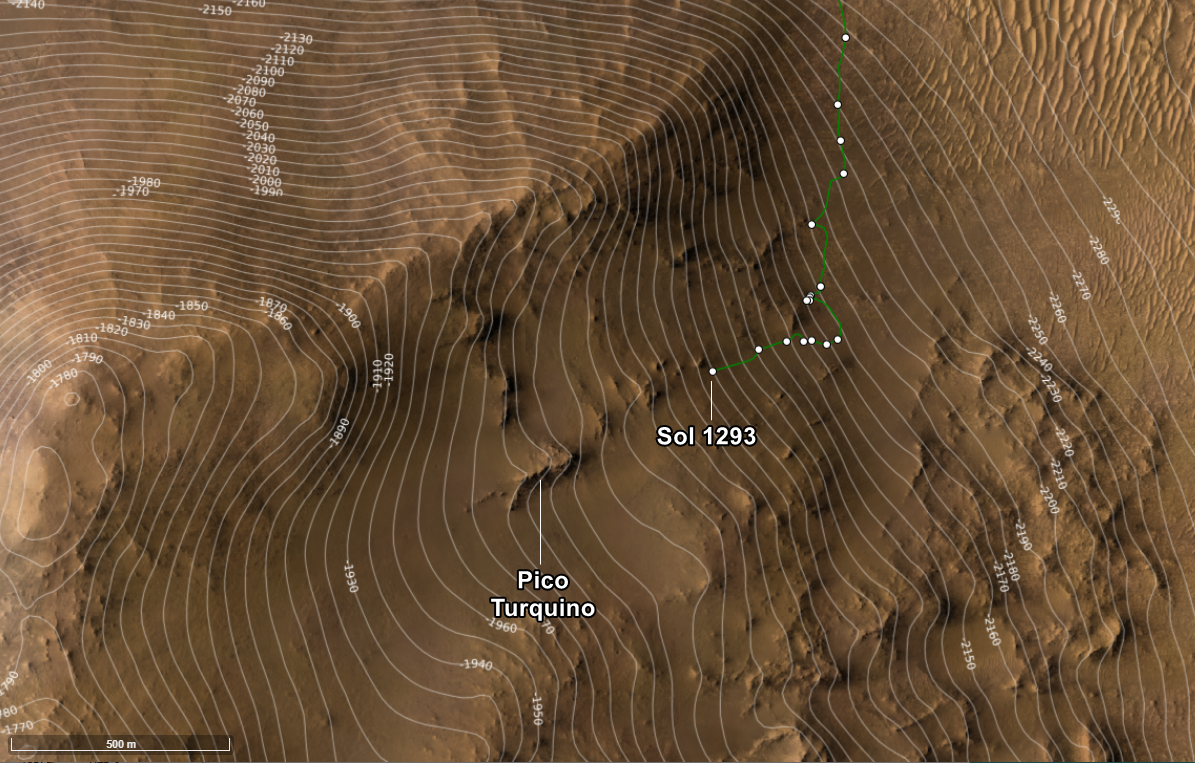
On the Road Again - Curiosity Rover Blog for Sols 4327-4328. Earth planning date: Monday, October 7, 2024

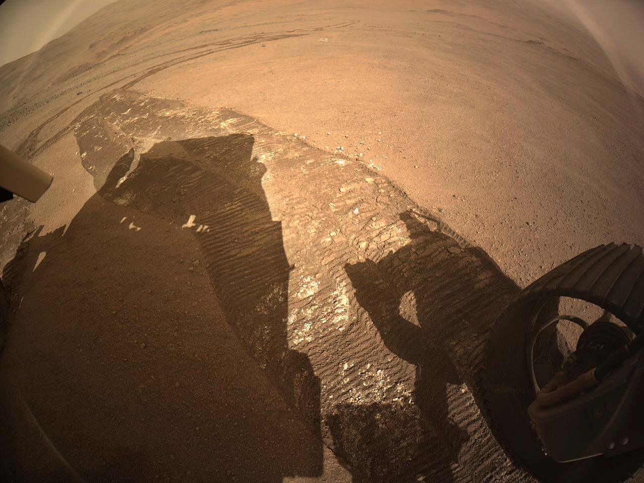
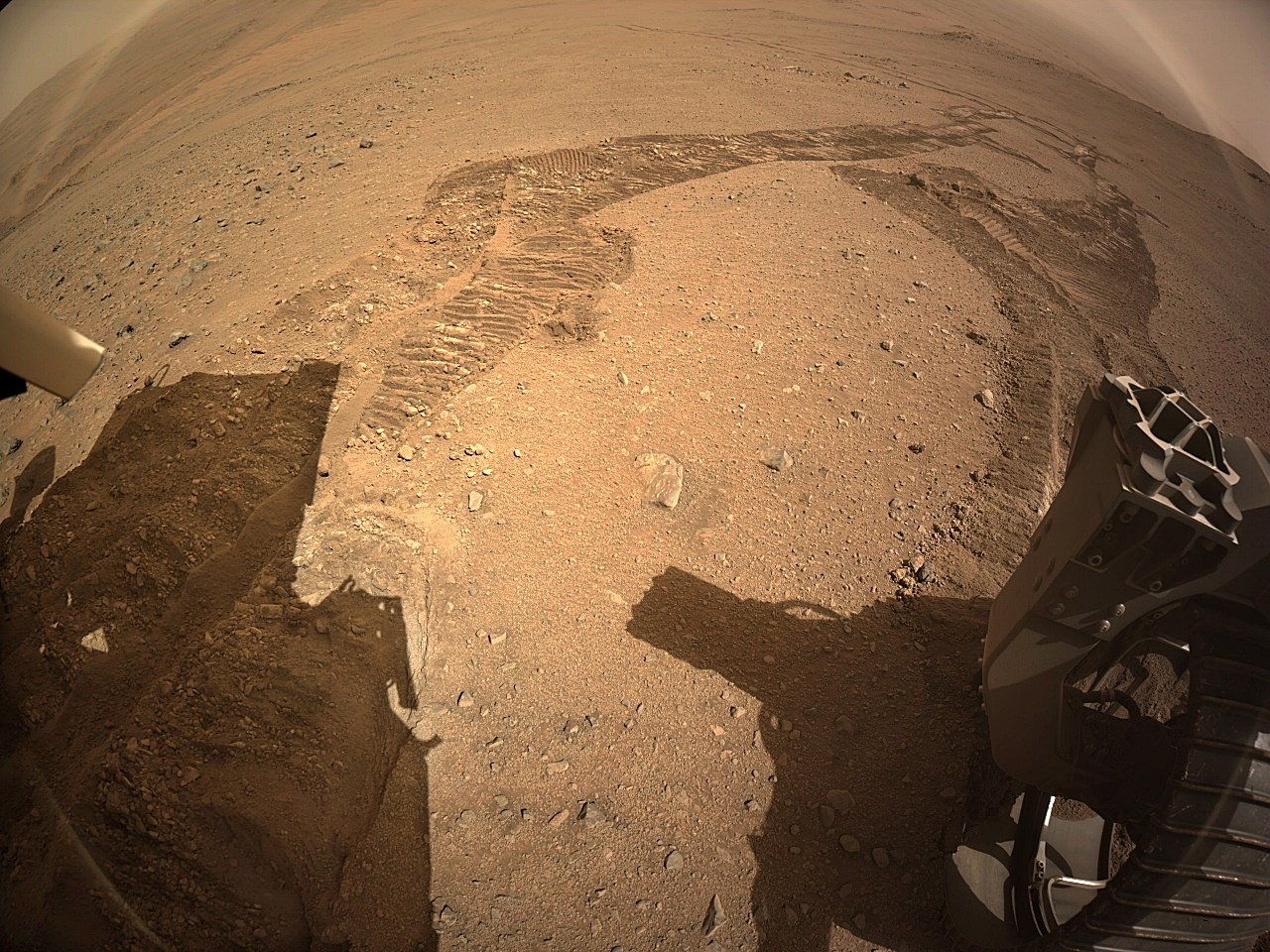
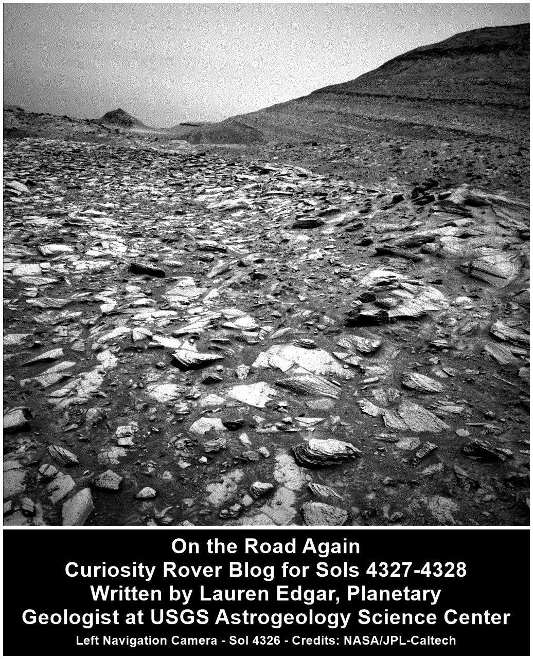
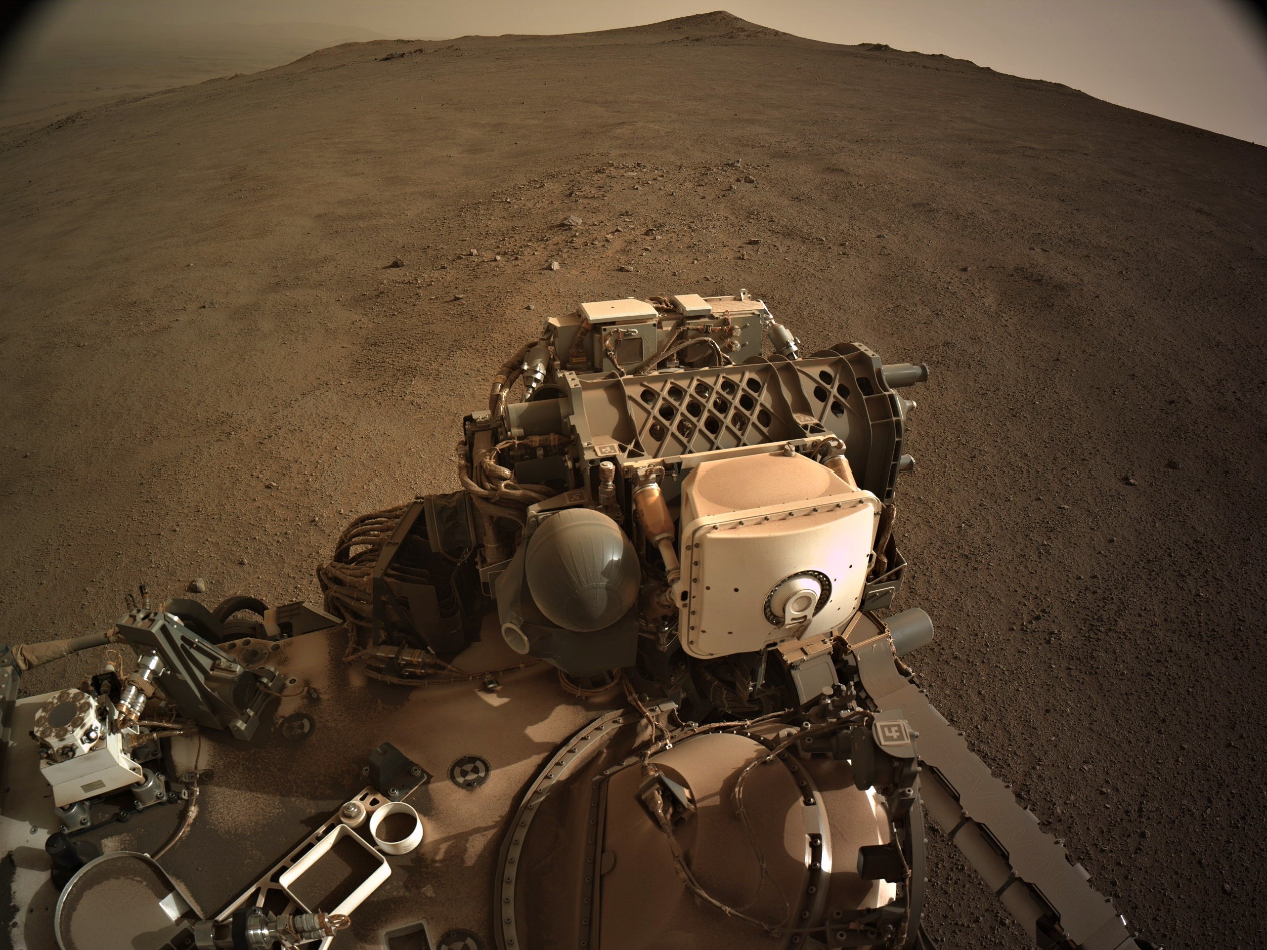
After successfully completing investigations within Gediz Vallis, Curiosity is back on the road through the Mg-sulfate (magnesium sulfate) bearing unit. The terrain under our wheels is a familiar collection of broken up blocks, and we’re keeping our rover eyes on the more distant stratigraphy and the deposits within the Gediz Vallis channel (as seen in the above Navcam image). Our traverse along this side of the channel is a great chance to understand the erosional and depositional history of Gediz Vallis from a different perspective, and to characterize variations in the sulfate unit.

I was on shift as Long-Term Planner today, and it was a pretty straightforward two-sol plan, with contact science on the first sol and driving on the second sol. The team planned a great collection of measurements to characterize the rocks in our workspace and more distant features.

The plan starts with remote sensing, including ChemCam LIBS on a gray, smooth slab at “Paloma Meadows,” followed by two long-distance RMI mosaics to assess the thickness and distribution of white clasts in Gediz Vallis. Then Mastcam will document Paloma Meadows and a distant dark clast at “Sky Parlor Meadow” to understand the variety of rock types and where they might have come from. The remote sensing block also includes a Navcam observation to search for dust devils. Later in the afternoon Mastcam will acquire a mosaic looking back towards “Whitebark Pass” including the white clasts (some of which were previously tied to observations of high sulfur) and the distribution of deposits within “Pinnacle Ridge.” Then Curiosity will use the instruments on the arm to assess one of the blocks in our workspace at “Pincushion Peak.” We’ll use the DRT, MAHLI, and APXS to assess the grain size, textures, and composition of a nodular block of bedrock. On the second sol Curiosity will acquire ChemCam LIBS and Mastcam of Pincushion Peak, which will make for a nice set of coordinated observations. The second sol also includes a long-distance RMI mosaic of an interesting dark block to assess sedimentary structures, and two Navcam observations to characterize atmospheric opacity and the movement of fines on the rover deck. Then Curiosity will continue driving, and take post-drive imaging to prepare for a similar plan on Wednesday. Looking forward to continuing to explore what’s under our wheels and on the horizon!

Written by Lauren Edgar, Planetary Geologist at USGS Astrogeology Science Center.

Source for this blog and the archive of all blogs (with all the links and the original raw images etc) https://science.nasa.gov/blog/sols-4327-4328-on-the-road-again/

These blog updates are provided by self-selected Mars Science Laboratory mission team members who love to share what Curiosity is doing with the public.

Dates of planned rover activities described in these reports are subject to change due to a variety of factors related to the Martian environment, communication relays and rover status.

Image credits: NASA/JPL-Caltech

[–] [email protected] 3 points 1 day ago

STOP STOP I’M GETTING A NOSEBLEED

I just posted the processed 4-tile image (glancing over it's shoulder at the tracks) Hope the nosebleed has ceased ;)

 
[–] [email protected] 3 points 1 day ago

Curiosity's single drive climbing record is currently 9.49 meters. Sadly I don't have the data for Spirit and Opportunity, but I'm guessing the record climb is now held by Perseverance with that climb of 32.419922 meters :)

9
submitted 1 day ago* (last edited 1 day ago) by [email protected] to c/[email protected]
 
  • Drive (path) distance 125.63 m (412.18 ft)
  • Point-to-point distance: 118.91 m (390.11 ft)
  • Climb: 32.42 m (106.36 ft)
 
[–] [email protected] 4 points 2 days ago

It has a sophistication motion detector. It basically maps its xyz position throughout the drive, and at the end of the drive it points it camera at where it calculates the sun should be and using a ND filter it captured an image, if the image is not in the middle of the image the team can adjust its xyz, It's very accurate. In addition they have orbital images of the terrain it is traversing, they can use that orbital imagery to pinpoint its location to less than a meter.


Post drive tiled NavCam. Awaiting the official drive details from JPL, I'll add the data as soon as I get it, but the RMC count hints that it may have been a long drive


This is just a screen capture from the official map: https://mars.nasa.gov/maps/location/?mission=Curiosity

North is up on this map

[–] [email protected] 3 points 1 week ago
[–] [email protected] 2 points 1 week ago

It was a huge challenge. There's a really good video out there on the challenges the team faced. I'll see if I can find it, but if anyone else has the link please share it here :)

[–] [email protected] 2 points 1 week ago

It's been challenging for sure in this soft(ish) regolith and the slope angle.

It also looks like there was a failed drive on sol 1287. After losing Spirit rover in a sand trap the rover drivers have been very careful traversing across loose sand.

I would not be surprised if they make a move to either side of this 'smooth passage'. The orbital imagery appears to show more favourable terrain (rougher) at the north and south edges. That diversion may only be required for the next 300 meters or so, as the distance between the contours widens a little after that, before narrowing again as they get nearer the rim crest. Whichever path they take it's going to take a lot of drives to reach the crest.

[–] [email protected] 2 points 1 week ago

It's got another 3 months left before it is archived.

I joined in January 2013, but lurked there for a long while before that.

I'll miss it, as I am sure many others will

[–] [email protected] 2 points 1 week ago

I expect a future book or two when the MSL and 2020 surface operations eventually come to a close. Knowing some of the players I don't feel they would be overtly controversial. but one may have to read a little between the lines :) Sadly I'm already as old as dirt, so I won't be seeing them on my coffee table before they nail my pine lid down. As for Neretva Vallis, you are not alone, it seemed more than a little odd that only one sample was taken. I know they have limited tubes left, but it sure feels like a missed opportunity...

[–] [email protected] 3 points 1 week ago

I'm sure there are a lot of folk that would appreciate and be very interested in any contributions you make, where you could shine a light on the many gaps there are in their understanding. It's probably not something you can measure in counting lots of upvotes on particular, but I'm pretty sure there is an audience out there for you.... Go for it whenever you see feature in any of the raw images or breaking down the results of a paper...

[–] [email protected] 2 points 1 week ago

They couldn’t spring for the S-VDB?

Those S-VDB's are a tad pricey 😂 😂 😂

I'd hate to think what a numismatist with deep pockets would pay for that VDB, if it was ever brought home, no matter what its PCGS grade ... 🤯

[–] [email protected] 3 points 1 week ago

they’re not fun.

100% agreed... Ingenuity should still be gathering data and the occasional images down in Neretva Vallis. Weather permitting it should do that for many years to come. A severe dust storm could dramatically reduce the output from its small solar array to a point where its heaters would not have sufficient power to prevent damage to its batteries and sensitive electronics.

[–] [email protected] 3 points 1 week ago

Thats pretty rad.

It is a very special view, but if not for the regional dust storm we are experiencing, we'd have a clear view of the crater floor where we landed and some of the areas we visited since landing. We'd even be able to see the Mars helicopter with the MastCam-Z cameras, granted it would only be a a few pixels across as it's close to 2 kilometers away (1.23 miles) still sat atop a sandy ripple in Neretva Vallis :) I hope the dust storm subsides before we drive over the crater rim, as the views will be memorable.

view more: next ›