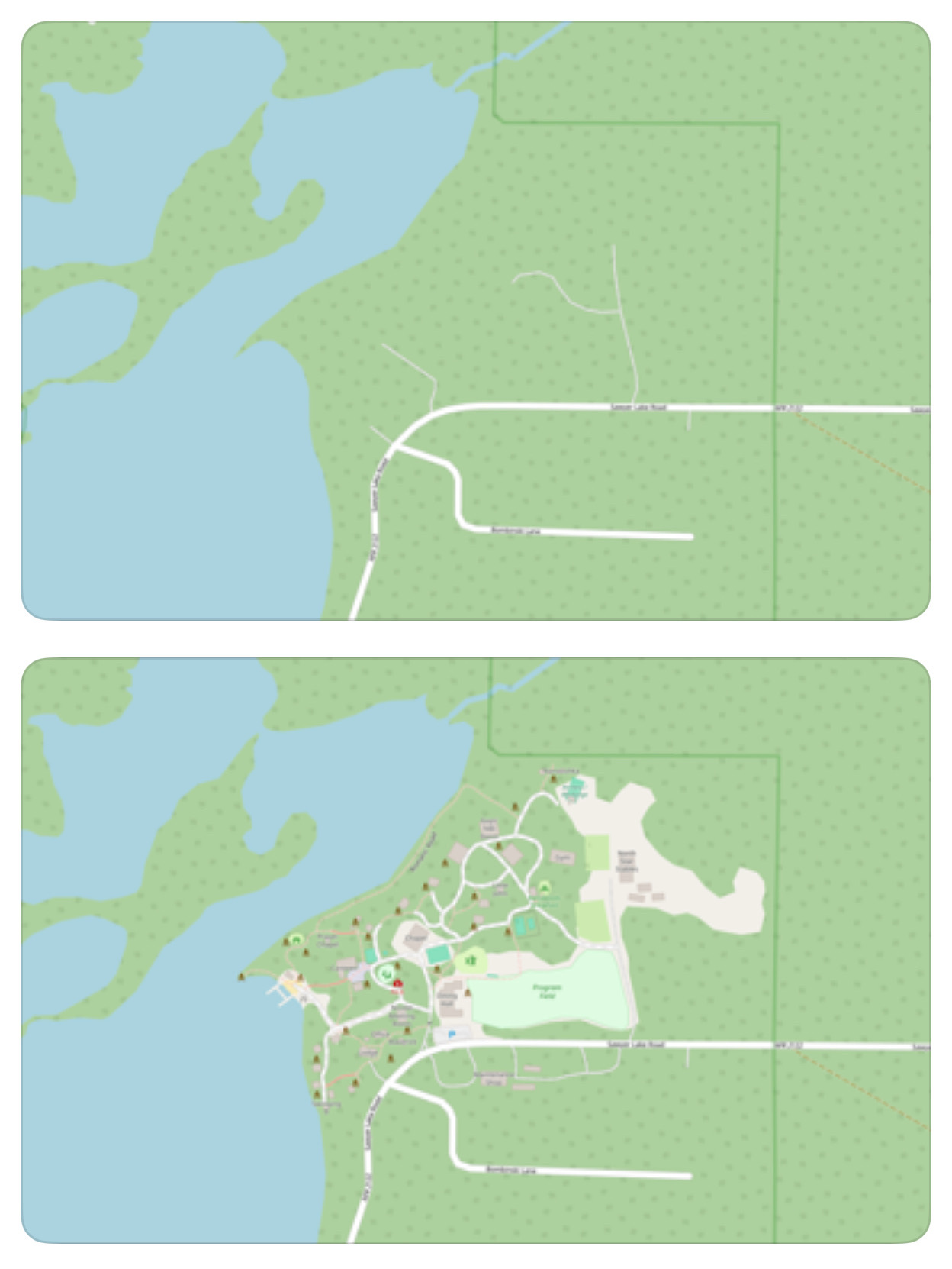
715
OSM > Google Maps (files.catbox.moe)
submitted 1 month ago* (last edited 1 month ago) by [email protected] to c/[email protected]

As requested by https://lemmy.one/u/[email protected] in the comment section of https://lemmy.world/post/16245139

OP I will delete this if you desire.

all 50 comments
sorted by: hot top controversial new old
[-] [email protected] 76 points 1 month ago

I went to a place ane someone had posted a photo of the employee pay starting rates and tagged is as a menu. A regional manager cost $95K.

[-] [email protected] 13 points 1 month ago

I'll have two regional managers and a water then

[-] [email protected] 6 points 1 month ago

Eat the rich

[-] [email protected] 1 points 1 month ago
[-] [email protected] 12 points 1 month ago

A regional manager cost $95K.

When you say it like that, I'm suddenly thinking of politicians for some reason 🤔

[-] [email protected] 46 points 1 month ago

can you actually? does OSM have data about restaurants etc?

[-] [email protected] 36 points 1 month ago

There are a lot of tags that can be used about restaurants: https://wiki.openstreetmap.org/wiki/Tag:amenity%3Drestaurant#Tags_used_in_combination

But it depends on which client display which tags.

[-] [email protected] 8 points 1 month ago

Which client is good for android? Especially if I want to edit?

[-] [email protected] 16 points 1 month ago* (last edited 1 month ago)

OSMAnd works quiet fine after you logged in. There are probably better ons, but I use it for specificall editing tags.

Be sure to checkout StreetComplete, which is a great way to contribute to OSM, especially for beginners.

This is unfortunately not for contributing photos.

[-] [email protected] 4 points 1 month ago

I tried OSMAnd but it's so fucking slow despite having already downloaded the map. Organic Maps is so much faster and smoother.

[-] [email protected] 6 points 1 month ago

Also wondering this

[-] [email protected] 4 points 1 month ago

Also curious. I tried a couple that just did not work well or were painful to use without premium.

If I can't tell if I like it for free, I'm not going to pay.

[-] [email protected] 3 points 1 month ago

Vespucci is awesome. I've used it extensively for years. It's only for editing though, not for navigation. I use OsmAnd (free pro features on f-droid)

[-] [email protected] 2 points 1 month ago

I don't use the same clients for viewing and editing.

I mostly use OSMAnd for viewing (but it can do editing too). To edit I use StreetComplete for easy, gamified, contribution and Vespucci if I need a full on editor. StreetComplete only ask you missing information about the things around you, if I want to add something new I use Vespucci).

[-] [email protected] 1 points 1 month ago

but it can do editing too

Oh?

[-] [email protected] 4 points 1 month ago

The only tag for a menu is:

website:menu=* – url to menu of the restaurant (pdf or webpage)

So there's no way to just upload a photo of the menu when you visit. And if a restaurant doesn't have a website with a menu, there's no way to add a menu.

[-] [email protected] 3 points 1 month ago

Basically no, you can't upload pictures. Even if you could add menu prices (I didn't check) it's not easy enough for enough people to bother, and will easily go out of date quickly. If it was as simple as uploading a photo it would be viable.

[-] [email protected] 16 points 1 month ago

I need to give it another shot. I couldn't find anything last time I tried to use it

[-] [email protected] 12 points 1 month ago

Then you can upload it. Be the change you wish to see in the world.

[-] [email protected] -1 points 1 month ago

Yeah or alternatively just use the free service that already has all the data

[-] [email protected] 10 points 1 month ago

You can contribute. It doesn’t take much to have all your favourite spots listed. You can try rapid editor.

[-] [email protected] 10 points 1 month ago

OSM for the win!

[-] [email protected] 10 points 1 month ago

I wanted to like osm but the apps were all quite janky last time I looked. Way too much effort to get something clean and usable.

[-] [email protected] 26 points 1 month ago

Have you tried Organic Maps? Works pretty well for me.

[-] [email protected] 11 points 1 month ago* (last edited 1 month ago)

I can give it a look. I doubt it has much where I live unfortunately because I'm not in a major metro area. That was another problem with OSM for me. Very incomplete due to lack of users in the area.

EDIT: I take it back, it already looks more complete than I would have expected. I'm surprised! This one does look quite a bit better than the other ones I tried so I'll see what I think. Appreciate the suggestion.

[-] [email protected] 6 points 1 month ago* (last edited 1 month ago)

+1 for Organic Maps. Shame it's not open source, but still. Ideal for walking and travelling.

Edit: I stand corrected!

[-] [email protected] 15 points 1 month ago* (last edited 1 month ago)

It is open source, licensed under the Apache License 2.0.

EDIT: Found it on f-droid: https://f-droid.org/en/packages/app.organicmaps/

[-] [email protected] 9 points 1 month ago
[-] [email protected] 2 points 1 month ago
[-] [email protected] 8 points 1 month ago

Which client can I use to do this easily?

[-] [email protected] 4 points 1 month ago

There isnt any that I am aware of. But i think you can upload in the official osm website...

[-] [email protected] 9 points 1 month ago

I contribute a bit and as far as I know the only editor that lets you upload pictures is MapComplete, but even then what you can upload them for is very limited. I do not believe OSM actually has an image database. The pictures I’ve uploaded are all stored on Imgur.

[-] [email protected] 8 points 1 month ago

It's a fine idea but feels like it's maybe past its prime in terms of active maintenance? Like I checked out my old neighborhood in the suburbs of a large US city and the primary road through it (which the area is named after and has a very big visible welcome sign indicating that) was misspelled. I don't have an account and didn't care to learn how to edit it, but I did drop a note flagging the error. Then I browsed some of the other notes and noticed they were all multiple years old. Even Manhattan was littered with months- or years-old notes with only a handful of them marked resolved. Maybe they were just hard edge cases not easily fixed, but it gave the impression of a database that has not been broadly maintained for years.

[-] [email protected] 11 points 1 month ago

The resolved ones get removed so the harder and harder notes remain. The main obstacle is usully that someone needs to actually go to the location, take notes and edit the map. It's a lot of work.

[-] [email protected] 5 points 1 month ago

Please consider creating an account and contributing occasionally. In the site OpenStreetMap.orgthe edit mode is very intuitive and easy, in addition there's Street Complete that makes a fun, quest like gamification for editing and adding information

[-] [email protected] 3 points 1 month ago

I mean you could be right but you can't do this on other platforms based on where you went last week.

OSM Edits

[-] [email protected] 1 points 1 month ago

You are a real hero bud!

[-] [email protected] 7 points 1 month ago

I tried OSM and it didn't bring me joy.

[-] [email protected] 8 points 1 month ago

The maps are pretty nice but the navigation is terrible (at least on OsmAnd). I tried to use it in my car for a while but I probably ended up spending a third more on gas because the routes were so bad.

[-] [email protected] 3 points 1 month ago

Yeah, it’s a cool idea, but IMHO, it’s going to need more members and a lot more money donated to the foundation for it to get really good. Good mapping is hard to do on the cheap. You need a lot of hardware and dedicated people.

[-] [email protected] 2 points 1 month ago* (last edited 1 month ago)

You also need telemetry and analytics to improve your real time navigation, which is understandably a big no-go for many people in the open source community.

[-] [email protected] 4 points 1 month ago

You probably don’t really need to know a who someone is to pull that off. You just need to know how quickly and effectively anonymous vehicles move through a particular area at a particular time. Cities have been analyzing this stuff with dumb cables and loops embedded in streets for decades.

[-] [email protected] 7 points 1 month ago
[-] [email protected] 4 points 1 month ago

Do you use an app? If so which?

[-] [email protected] 7 points 1 month ago

Organic Maps is by far the best client imho and it has a special outdoor layer when on trails.

[-] [email protected] 2 points 1 month ago

Organic maps is simple and easy. If you want a power tool, OsmAnd is amazing.

[-] [email protected] 1 points 1 month ago

I'd love to know too

[-] [email protected] 3 points 1 month ago

OK but how do I post to open street maps with photos? Can I do it from organic maps?

this post was submitted on 07 Jun 2024
715 points (97.6% liked)

memes

8761 readers
3285 users here now

Community rules

1. Be civilNo trolling, bigotry or other insulting / annoying behaviour

2. No politicsThis is non-politics community. For political memes please go to [email protected]

3. No recent repostsCheck for reposts when posting a meme, you can only repost after 1 month

4. No botsNo bots without the express approval of the mods or the admins

5. No Spam/AdsNo advertisements or spam. This is an instance rule and the only way to live.

Sister communities

founded 1 year ago
MODERATORS